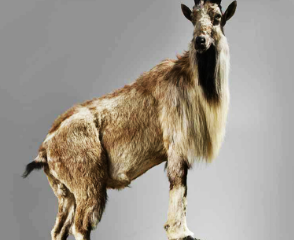
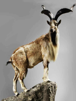
Connect with us

Article

Rupal Glacier: A Majestic Icy Giant in the Heart of the Himalayas

Published

on

The Rupal Glacier is a breathtaking and formidable glacier located in the Rupal Valley, in the Astore District of Pakistan’s Gilgit-Baltistan region. This massive ice flow is nestled beneath the towering Nanga Parbat, the ninth-highest mountain in the world, and is part of the greater Himalayan mountain range. The Rupal Glacier is not just a geographical marvel but also a significant contributor to the region’s ecosystem and a point of interest for mountaineers and trekkers from around the world.

Geographic Location and Surroundings

The Rupal Glacier is situated on the southern slopes of Nanga Parbat, often referred to as the “Killer Mountain” due to the challenges it poses to climbers. The glacier lies within the Rupal Valley, a pristine and remote valley that is characterized by its lush green meadows, dense forests, and the stunning backdrop of towering peaks. The valley is accessible from the town of Astore, and the journey to the glacier involves a trek that is as challenging as it is rewarding, offering spectacular views of the surrounding landscapes.

Physical Characteristics

  • Type: Valley Glacier
  • Length: Approximately 13 kilometers (8 miles)
  • Width: Varies; narrow at the head, wider at the lower end
  • Elevation: Ranges from around 3,500 meters (11,500 feet) at the terminus to over 6,000 meters (19,700 feet) near Nanga Parbat
  • Surrounding Peaks: Nanga Parbat (8,126 meters), Laila Peak, Rupal Peak

Glacial Features

  • Crevasses: Deep fissures present due to the glacier’s movement over uneven terrain.
  • Moraines: Extensive lateral and terminal moraines composed of rock debris carried by the glacier.
  • Icefall: Steeper sections of the glacier where ice movement causes it to break into blocks and form seracs.

Climate and Environment

  • Temperature: Cold alpine climate, with temperatures often dropping below freezing, particularly in the higher elevations.
  • Precipitation: Primarily snowfall, which feeds the glacier, with minimal rain due to the high altitude.
  • Retreat and Advance: The glacier has shown signs of retreat, similar to many glaciers worldwide, due to global warming and climate change.

Hydrological Importance

  • Water Source: The glacier is a crucial source of meltwater that feeds into the Rupal River, a tributary of the Astore River, which eventually contributes to the Indus River system.
  • Seasonal Flow: Melting increases in the summer, leading to higher river flows, essential for agriculture and daily use in the region.

Access and Trekking

  • Nearest Town: Astore, approximately 50 kilometers from the glacier.
  • Trekking Route: Accessed via a trek through Rupal Valley, often starting from the village of Tarashing.
  • Trek Difficulty: Moderate to strenuous, depending on weather conditions and altitude acclimatization.
  • Best Time to Visit: June to September, when the weather is relatively stable, and snow cover is minimal.

Mountaineering Significance

  • Rupal Face: The glacier is the gateway to the Rupal Face of Nanga Parbat, a 4,600-meter vertical wall that is one of the most challenging climbs in the world.
  • Historical Expeditions: The first successful ascent of the Rupal Face was made in 1970 by an Austrian team, a milestone in mountaineering history.

Ecological and Cultural Context

  • Flora and Fauna: The surrounding areas of the glacier are home to alpine flora and fauna, including rare species adapted to the harsh environment.
  • Local Communities: Inhabited by the Shina and Balti people, who have a deep cultural connection to the land and rely on its resources for sustenance.
  • Cultural Significance: The glacier and surrounding mountains hold spiritual and cultural importance for the local communities, often featuring in folklore and traditional practices.

Article

Where the Sky Meets the Earth: The Breathtaking Beauty of Deosai Plains, Pakistan

Published

on

By

Nestled high in the northern reaches of Pakistan, the Deosai Plains stand as one of the most awe-inspiring and untamed landscapes on Earth. Known as the “Land of Giants,” these plains stretch across a vast plateau at an altitude of approximately 13,000 feet (4,000 meters) above sea level, making them one of the highest plateaus in the world. This unique natural wonder, located in the Gilgit-Baltistan region, offers a stunning blend of sweeping vistas, pristine wilderness, and rare wildlife, making it a true gem in Pakistan’s natural heritage.

A Natural Wonderland of Unparalleled Beauty

The Deosai Plains are often described as where the sky meets the earth, and for good reason. Standing on the vast expanse of the plateau, it feels as if you are at the very edge of the world, with nothing but the blue sky above and the sprawling grasslands below. The wide, open spaces are interrupted only by the occasional rolling hill, a distant snow-capped peak, or a river weaving its way through the landscape. The air is crisp and clear, and the silence of the plains is occasionally broken by the soft rustle of the wind or the distant call of a bird.

In the spring and summer months, Deosai transforms into a vibrant sea of wildflowers, with colorful blooms carpeting the plains as far as the eye can see. The sky remains an endless shade of blue, and at night, the starlit sky feels close enough to touch, offering some of the most incredible stargazing experiences anywhere in the world.

A Haven for Wildlife

One of the most remarkable aspects of the Deosai Plains is its rich biodiversity. It is home to a variety of rare and endangered species, most notably the Himalayan brown bear, which is found in very few places on Earth. Thanks to conservation efforts, the population of these bears is slowly recovering in the region. Visitors may also encounter other wildlife, including snow leopards, golden marmots, ibex, and a variety of birds, making it a haven for nature lovers and wildlife enthusiasts.

The Deosai National Park, established in 1993 to protect the wildlife and ecosystem of the region, plays a crucial role in preserving the unique flora and fauna that thrive in this high-altitude environment. The park is a testament to Pakistan’s commitment to conserving its natural heritage while allowing people to experience the wild beauty of the Deosai Plains.

Cultural and Historical Significance

The name “Deosai” translates to “Land of the Giants” in the local language, which is steeped in legend and folklore. Local myths tell of giants that once roamed the area, and this name adds a sense of mystique to the plains’ vast and otherworldly landscape.

For centuries, the Deosai Plains have also served as a natural boundary between the Karakoram and the western Himalayas. Historically, the area has been traversed by nomadic herders, and it still holds cultural significance for the indigenous communities that live in the surrounding valleys.

An Unforgettable Experience for Adventurers

Deosai is a dream destination for adventurers and outdoor enthusiasts. The rugged, untouched beauty of the plains provides a perfect setting for hiking, camping, and photography. Trekkers are drawn to the challenge of exploring the vast wilderness, where they can witness stunning landscapes and encounter rare wildlife in their natural habitat.

Sheosar Lake, located within the Deosai National Park, is one of the highest lakes in the world and a must-visit for travelers to the region. The serene, crystal-clear waters of the lake reflect the surrounding snow-capped peaks, creating a breathtaking view that is often considered one of the most beautiful in Pakistan.

Challenges and Conservation

Despite its beauty, the Deosai Plains face challenges from environmental changes and human activity. Climate change poses a significant threat to the delicate ecosystem of the region, affecting the wildlife and plant species that call Deosai home. Additionally, increased tourism has raised concerns about the impact on the environment. It is essential that conservation efforts continue to protect this fragile ecosystem for future generations to enjoy.

Conclusion: A Natural Wonder That Captures the Imagination

The Deosai Plains are more than just a natural wonder; they are a place where the raw beauty of the earth and sky come together in perfect harmony. Whether you’re standing on the vast plains gazing at the horizon, observing the rare wildlife, or camping under a blanket of stars, Deosai offers an experience like no other. It is a reminder of the untouched beauty that still exists in the world and the importance of preserving such places for the future. For those seeking adventure, tranquility, and a connection with nature, Deosai Plains is a must-visit destination—where the sky truly meets the earth, and nature’s breathtaking beauty is on full display

Continue Reading

Article

Al-Battani Arab Astronomer and Mathematician

Fariyal Mir

Published

on

The Syrian land took the honor to produce intellects like Abu Abd Allah Muhammad Ibn Jabir Ibn Sinan Al-Battani Al-harrani As-Sabi. He was born around 858 and left the world in 929 near Iraq. The Muslim intellect had gained expertise in astronomy and mathematics and contributed to the world.

The astronomer Al-Battani worked in astronomy for 40 years and was able to produce data using simple instruments. He worked on the books of Ptolemy (Roman astronomer and mathematician) and refined the values for solar years and seasons of the year. The superman had corrected the minute difference. For instance, in Ptolemy’s book, the year length was given as (365 days, 5 hours, 55 minutes, and 12 seconds) while he calculated it as (365 days, 5 hours, 48 minutes, and 46 seconds). He also calculated 54.5 per year for the precession of the equinoxes and put the value of 23 35’ for the inclination of the ecliptic (O’Connor & Robertson, 1999).

Further, he was the foremost to explore Azimuth and Nadir and determined their points in the sky. It would not incorrect to call him the founder of astronomical basis which became a model for all the astronomers after him. Even today his works are used and acknowledged. As the French astronomer, Lalande said that Al-Battani is one of the astronomers’ leaders around the world.

Moreover, he had given a more accurate description of the motion of the sun and moon along with the motion of five planets. He never limited himself to observation but had written books as well. One of his books Al-Zij which contains mathematical tools to describe astronomical problems.

The astronomist Al-Battani had contributed to mathematics as well which is undeniable. His mathematical contribution is not limited to astronomy but is more valuable in the engineering field. He had made trigonometric functions like cosine, tangent, cotangent which are then assembled in technology. He had provided the table for cotangent.

Muslim scientists have served humanity from a time when there was no advancement but they brought it out for all. Today many Muslims do not know about the behind story of modern advancement. There should need to be research about all those legends who passed away millenniums ago but their works are still in use. We would like to thank them on behalf of the whole of humanity.

Continue Reading

Article

Udren Glacier: A Hidden Gem in Chitral’s Majestic Landscape

Published

on

By

The Udren Glacier, nestled in the heart of the Chitral region in Pakistan, is a pristine natural wonder that remains relatively unknown to the broader public. Situated in the shadows of some of the most imposing peaks of the Hindu Kush mountain range, this glacier exemplifies the awe-inspiring beauty and environmental importance of the northern areas of Pakistan. Chitral, known for its diverse landscapes, offers a mix of deep valleys, towering mountains, and expansive glaciers like Udren, making it a key destination for nature lovers and mountaineers alike.

Location and Access

Udren Glacier is located in the Upper Chitral District, part of the larger Chitral valley that stretches along the western part of the Hindu Kush range. The glacier is situated in a remote region, making access challenging but rewarding for adventurous trekkers and climbers. The glacier is close to the Tirich Mir massif, the highest peak in the Hindu Kush, making it part of a larger, dramatic mountainous landscape.

The most common access point for Udren Glacier is through the village of Tirich, a base camp for mountaineers aiming to scale Tirich Mir. From here, adventurers can trek towards the glacier, passing through rugged terrain, serene meadows, and traditional Chitrali villages. The journey to Udren Glacier offers a glimpse of the region’s untouched wilderness and an opportunity to connect with the local culture.

Geographical Features

Udren Glacier is a large, perennial glacier that serves as a critical water source for the surrounding valleys. It is part of the glacial system that feeds into the Mastuj River, which in turn contributes to the Chitral River. Like many glaciers in the Hindu Kush region, Udren is a key player in the hydrological cycle, providing essential meltwater for agriculture and human consumption in the valley below.

The glacier itself is characterized by its massive ice formations, crevasses, and moraines, all set against a backdrop of steep, snow-capped peaks. The area around the glacier is known for its alpine flora and fauna, offering a habitat for species adapted to the cold, high-altitude environment.

Climatic Importance

Like other glaciers in the Hindu Kush-Himalaya region, Udren Glacier is facing the impacts of climate change. Glaciers in this region act as “water towers” for millions of people, providing meltwater that sustains ecosystems, agriculture, and human populations downstream. However, rising global temperatures have led to the accelerated melting of glaciers, including Udren, which poses risks of glacial lake outburst floods (GLOFs) and long-term water scarcity in the region.

For local communities, the Udren Glacier not only provides water but also plays a role in maintaining the local microclimate. The glacier’s meltwater is crucial for irrigation, particularly in the high-altitude farming systems that are typical of the region.

Mountaineering and Adventure Tourism

The Udren Glacier is part of a broader network of glaciers and peaks that make Chitral a magnet for mountaineers. Trekkers and climbers often pass through Udren Glacier en route to Tirich Mir or other peaks in the Hindu Kush range. While not as well-known as Baltoro or Biafo glaciers in the Karakoram, Udren offers a more secluded and less-trodden path for those seeking adventure in one of the world’s most rugged mountain landscapes.

Visitors to Udren Glacier can also experience the rich cultural heritage of the Chitrali people. The region is home to a unique blend of ancient traditions, languages, and lifestyles, offering a glimpse into a way of life that has persisted for centuries in harmony with the harsh mountain environment.

Continue Reading

Most Popular

English اردو